
Today on Travel Tuesdays I want to take you back to June 20, 2015.
That was the day that Chris and I arrived back in the U.S. after years of living in Europe on our current Plan G adventure.
Plan G actually started a few months before that, on March 31, 2015, when we left Germany (where we’ been living for 3.5 years) and turned into “tourists” in the EU. (For more on the complexities of that, as well as why our current travel adventures are called Plan G, I refer you to old blog posts here and here and here and here.)
Anyway, here’s a breakdown of our Plan G travel so far:
Phase 1: March 31-2015-June 20, 2015 : Travels in Europe
Phase 2: June 20, 2015-January 7, 2016: Travels in North America, East to West
Phase 3: January 7, 2016-September 21, 2016: Travels in North America, West Coast
Phase 4: September 21, 2016-October 16, 2016: Travels Down Under
Phase 5: October 16, 2016-November 21, 2016: Travels in North America, West to East
Phase 6: November 21, 2016-present: Travels in Europe, again
A while back Chris wrote a lovely little interactive map program for me to use to plot our travels. He made it back when we were in Phase 2 of the trip, but I never got around to actually populating the map with all our stops, and therefore never shared it.
But I have now made the Phase 2 map:
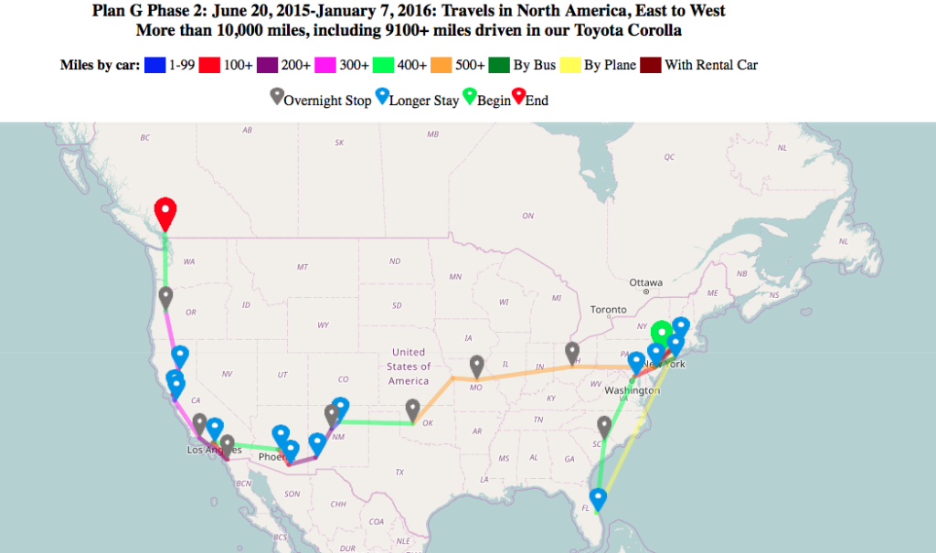
Plan G Phase 2 Travels in North America, East to West
That’s a static screenshot of the interactive Phase 2 map. Click on that image, and a new window will open with the interactive map. You can can zoom in and out in the interactive map to see more details, plus you can click on the markers to get more information about the trip.
That Phase 2 map shows all the places we visited from the moment we arrived back in the U.S. (on June 20, 2015) until we got to Vancouver, BC on January 7, 2016. The means it represents more than 9,100 miles of driving around North America in the little Toyota Corolla that we bought (used) in Florida in August of 2015, as well as additional mileage for travel we did by plane, bus, and rental car during that same 6 month period. Seeing everything laid out on the map is kind of fun; while I knew we travelled a lot in a relatively short period of time, I hadn’t realized just how much until I saw it all on the map all at once.
Anyway, I encourage you to let me know if you have any feedback about working with or understanding the map. As a usability professional in another lifetime, I’d like to incorporate changes based on user feedback into the maps for the rest of the phases ![]()
Where’s the Idaho stop?
Do you get frequent traveler miles?
@Mom – Idaho comes later, in October 2016. The map in this post is only for the first 6 months in North America, util January 7, 2016
@Jack – our Toyota Corolla doesn’t have a frequent traveler plan, unfortunately. An oversight, to be sure ..
You certainly have the right vehicle for reliable travel. The Toyota Carolla is virtually indestructible.
very interesting. I checked out all the stops which brought back some memories. I didn’t see doug and phyllis name with tempe, arizona. there were lots of interesting people at various places.
Thanks, Stan. I actually didn’t put anyone’s names in for any of the stop, I don’t think. There were definitely lots of interesting people we visited in many of the places!